


DALLAS – After a tornado reportedly damaged part of North Texas Saturday night, a new tornado watch was issued for much of the Dallas-Fort Worth Metroplex overnight into Sunday morning.
Live weather updates
Keep track of severe weather alerts here.
Fatality confirmed: 12:20 a.m.
Officials in the Runaway Bay area confirmed that one person has been confirmed dead after a suspected tornado hit the town. At least 20 families were displaced, they said, and numerous people were injured.
Emergency crews from Wise County and the American Red Cross are assisting recovery.
A Reunification Center has been established at 513 Port O’ Call Drive, Runaway Bay. Families seeing loved ones or assistance are encouraged to report there.
Severe warnings: 12:15 a.m.
Flash flood warnings were in effect until past 2 a.m. Sunday for Tarrant County. Severe flooding was seen in the Fort Worth area.

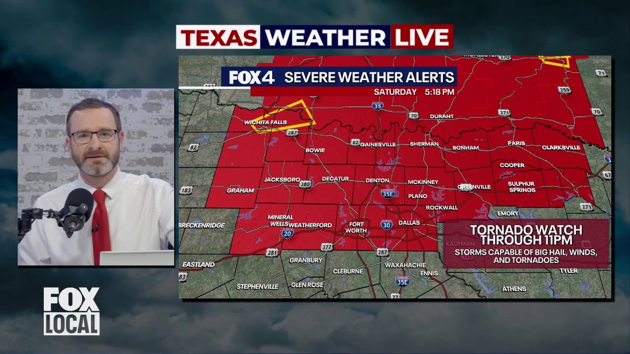
Tornado watch: 11:30 p.m.
A tornado watch was issued for much of North Texas until 5 a.m. Sunday. The area of the watch includes the counties of Wise, Henderson, Ellis, Parker, Hunt, Dallas, Fannin, Johnson, Rockwall, Tarrant, Navarro, Denton, Kaufman, Van Zandt, Rains, Collin, Delta, Hopkins, Lamar and Cooke.
Severe watches and warnings: 11 p.m.
Tornado warnings were canceled slightly before they were set to expire, but severe watches remained in effect for much of North Texas until near or past midnight.
Tornado warnings: 10:15 p.m.
A tornado warning was issued for the counties of Parker and Tarrant until 11 p.m., with the storm set to move into the Fort Worth area around 10:20. Large hail was reported falling in the area of the storm.
A severe thunderstorm warning was also put in effect for several counties until 11 p.m.
A flash flood warning was issued for the counties of Jack and Wise until 12:15 a.m.
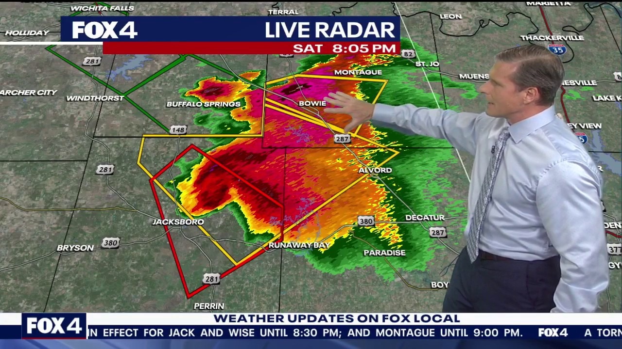
Tornado warnings: 9:30 p.m.
Around 8 p.m., a tornado warning was issued for Jack County, with a powerful storm pushing southeast toward the Metroplex with heavy rain and high winds. The warning was set to expire at 8:30 p.m.
Another tornado warning was issued until 9:15 p.m. for the counties of Jack and Parker until 9:30 p.m.
Yet another was issued for Wise County until 9:30 p.m.
Tornado warning issued in North Texas
Around 8 p.m., a tornado warning was issued for Jack County, with a powerful storm pushing southeast toward the Metroplex with heavy rain and high winds. The warning was set to expire at 8:30 p.m.
Tornado watch: 5:30 p.m.
The watch was issued just before 4 p.m. Saturday until 11 p.m. The area of effect includes the counties of Red River, Fannin, Lamar, Rockwall, Tarrant, Collin, Dallas, Delta, Cooke, Denton, Jack, Wise, Hunt, Parker, Hopkins and Palo Pinto.
Saturday severe weather forecast
The area of concern includes the Dallas-Fort Worth Metroplex, the I-20 corridor, and areas to the north of DFW. Storms were beginning to develop near Wichita Falls around 5 p.m., with additional potential for development near Graham and Jacksboro. If storms break through a weak atmospheric cap, they could move into the Metroplex or areas just north of it.

What’s next:
The primary concern on Saturday night is large hail, potentially reaching baseball size or larger, along with damaging wind gusts of 60–70 mph. While only a few storms are expected to form, any that do could become severe quickly. There is also a tornado risk, especially after sunset and mainly across counties near the Red River.
Storms already forming are expected to move east and possibly southeast, reaching parts of the I-35 corridor by around 8 p.m. and continuing through North Texas until roughly midnight. The greatest risk appears to be for northern parts of the Metroplex and surrounding counties, with ongoing monitoring and updates expected throughout the evening.
The Source: Information in this article comes from the FOX 4 Weather Team.
