


ATLANTA, Ga. (Atlanta News First) — The heat continues into Saturday before a cold front pushes through the area into Sunday. We’ll see some changes in the way of milder weather behind the front.
Saturday: Another Warm Day
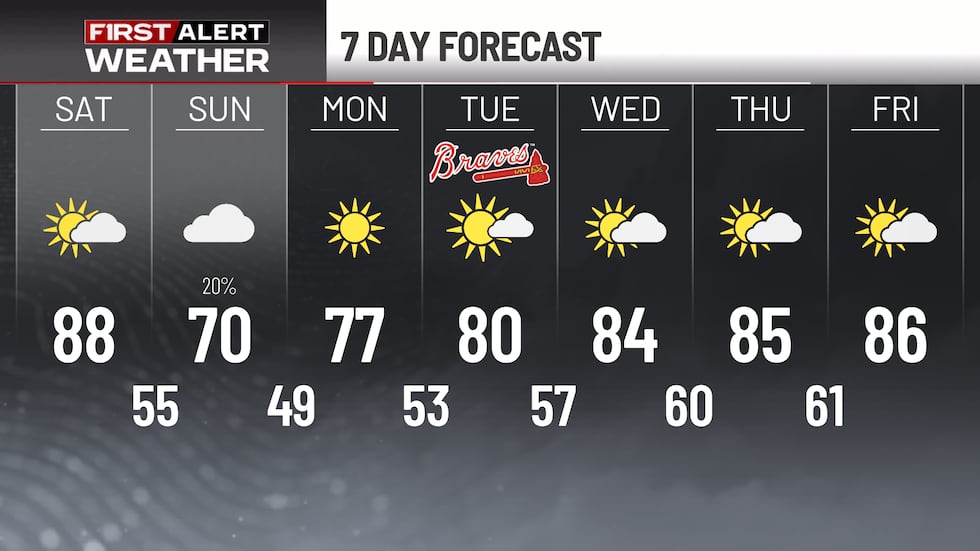
Saturday is shaping up to be another beautiful day, but it’ll be hot. Highs will climb into the mid to upper 80s across the metro area, with some spots in central Georgia potentially pushing toward 90 degrees. It’ll be mostly sunny with just a few clouds building in the afternoon.
However, there’s something to watch: fire danger will remain elevated Saturday. The combination of warm temperatures, low humidity, and dry vegetation means conditions will be ripe for fire spread if any ignitions occur.
Sunday: A Few Showers Early, Then Clearing Out
Here’s where things change. A cold front will move through late Saturday night into Sunday morning, bringing a chance of showers, mostly for the far NW parts of the state. Any shower activity will be completely wrapped up by late morning.
Once that front passes through, most of Sunday will be dry. You can plan outdoor activities for the afternoon and evening without much weather concern. Highs Sunday will only be in the upper 60s and lower 70s.
Don’t expect much rain from this system — amounts will be minimal, around a tenth of an inch or less. While we could certainly use the moisture, this won’t make much of a dent in the ongoing dry conditions.
Looking Ahead
High pressure builds back in Monday, bringing dry conditions and near-normal temperatures to kick off the work week. Temperatures will gradually warm through the week, with highs climbing back into the mid to upper 80s by Thursday.
Copyright 2026 WANF. All rights reserved.
